There have been a number of exciting changes at 10.1 in analysis and geoprocessing. There are two major new features: geoprocessing packages and geoprocessing services that make sharing and publishing workflows easy and quick. We have introduced some key changes to many existing tools (for example, spatial join, the ability to import and export KML data, new data types support in ModelBuilder toolbox) and, of course, there are a number of new tools.
Geoprocessing packages
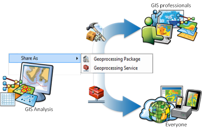
Within our everyday work, information sharing is critical, and it may include data, analysis, and/or results. Packages are created by right-clicking a result in the Results window and choosing Share As > Geoprocessing Package.
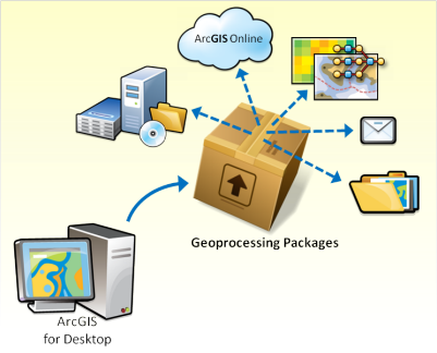
At 10.1 geoprocessing packages not only make it much easier to share tradecraft between professionals, but they also have many other uses:
- As project deliverables:
Clients can be given access to the final results, including the data and any models and maps, which they can use and present as they require. This allows you to deliver both transparency in your analysis and a rich suite of resources to clients.
- To share with colleagues:
Within a project team, individuals can concentrate on their areas of expertise and collectively share their results and/or consolidate their individual analysis at key points in the project.
- To share with data providers:
If you're working with external data providers or other teams, you can easily feed back any derived data and/or workflows.
- On ArcGIS.com
Remember, you can set up your own groups on ArcGIS.com, and you can share within that community only or share your workflows publicly.
- For archiving:
When a project is completed, all the data, analysis, and results can be stored as a geoprocessing package for easy data and project recovery if required in the future, while also freeing up valuable space for current projects.
Geoprocessing services
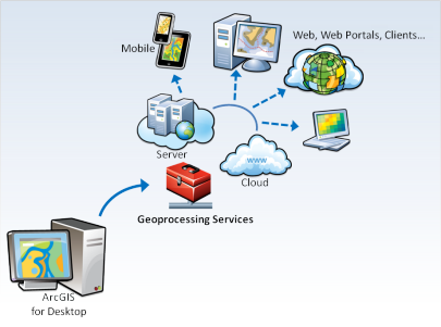
Increasingly, we are starting to develop services that can be accessed via the web by web-enabled clients, such as ArcGIS Explorer, ArcGIS Desktop, ArcGIS Online, and custom web applications built with web-based APIs such as JavaScript, Silverlight, and Flex. At ArcGIS 10.1, you can create geoprocessing services by right-clicking a result in the Results window and choosing Share As > Geoprocessing Service. This opens the Share As Service step-by-step wizard and the Service Editor dialog box.
Developing models or scripts?
For script or model tool developers, there are two new read-only variables that can be accessed from geoprocessing environments: Scratch GDB and Scratch Folder. These environment variables contain a path to a scratch file geodatabase and scratch folder, respectively, that are guaranteed to exist when your tool is run. Other new environment settings include Cartographic Partitions, NoData, and Resampling Method.
There are also a number of Python improvements, including fast cursor performance and support for developing Python add-ins. More details can be found on the new Python resource center.
Performance improvements
In the 10.1 release, we have been able to provide a number of performance improvements in several areas, including:
- Faster tools when working with selections.
- Topo Engine is faster in many cases for large, dense datasets. This means improvements in operations such as overlays.
- Calculate field is faster with both versioned and nonversioned data.
Within the Spatial Analyst extension:
- Tools are faster with geodatabase rasters.
- In-memory workspaces support rasters.
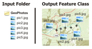
ArcGIS 10.1 includes new functionality for GPS data. It is now easier to work with GPS data using a number of new tools, such as:
- GPX To Layer
- GeoTagged Photos To Points
- Match Photo To Row By Time
Toolbox development
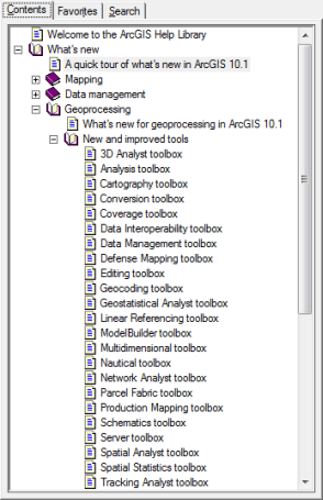
There are changes to existing tools and new toolsets in 18 toolboxes. Full details can be found by following the links provided below. Here are a few highlights from a variety of toolboxes:
If your feature class uses a projected coordinate system and covers a large area, or you are using very large buffer distances, the resultant buffer distances will differ across your area due to distortions in the projection. Geodesic buffers more accurately represent distances on the earth's surface. Geodesic buffers will be automatically created if the input feature class has a geographic coordinate system and the buffer distance is specified in linear units, such as meters and feet (as opposed to angular units, such as degrees).

The Tabulate Intersection tool calculates the intersection between two feature classes and cross-tabulates the area, length, or count of the intersecting features.
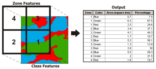
It can be used to answer many questions, such as what proportion of my study area's zones are covered by different land cover classes. It can also be used to translate between different geographical boundaries; however, users should be aware of issues involved in such analysis, in particular the modifiable area unit problem (MAUP; Openshaw, 1984). In cases where this tool is not suitable for translating between boundaries, another new method, Areal Interpolation in the Geostatistical Analyst extension, may be more appropriate.
The Exploratory Regression tool provides a data mining tool. This tool evaluates all the possible combinations of input explanatory variables, looking for ordinary least squares (OLS) regression models that best explain the input-dependent variable. It is similar to stepwise regression methods in that it seeks to find models with high Adjusted R2; however, this method additionally seeks to find models that meet all of the requirements and assumptions of the OLS method.
Here are links to details of the changes made at 10.1 for each toolbox
Extensions: Geostatistical Analyst
A new interpolation tool, Empirical Bayesian Kriging, has been introduced at 10.1. This method accounts for the error in estimating the underlying semivariogram through repeated simulations, unlike other kriging methods that use a single semivariogram, which can lead to underestimates in standard errors of prediction.
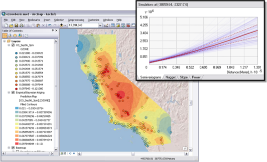
Empirical Bayesian Kriging uses three new parameters (not used in other kriging methods) that allow better models to be specified. Different data will require a different number of points to be included in each subset and this can now be defined. A further refinement, to suit your specific data, can be made using the overlap factor. This will affect how smooth an output surface is created. Finally, the number of semivariograms to be simulated can be specified for each subset.
Network Analyst
In Network Analyst, a new Server toolset has been added that contains tools designed primarily to set up web services for solving network analyses and to retrieve live traffic and traffic-incident data from web services. This allows visualization and network analysis using real-time traffic conditions. The new Solve vehicle routing problem tool is similar to the Make Vehicle Routing Problem Layer but significantly simplifies the processing, specifically when setting up a geoprocessing service.
Further information
This article provides a brief introduction into just some of the new functionality in analysis and geoprocessing in ArcGIS 10.1. There are many more new and improved tools with complete details being outlined in New and improved tools. If you are interested in learning what’s new throughout the ArcGIS product line, details are outlined in A quick tour of what's new in ArcGIS.
This story was contributed by Linda Beale, analysis and geoprocessing team
