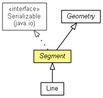
 com.esri.core.geometry.Geometry
 com.esri.core.geometry.Segment
|
||||||||||
| PREV CLASS NEXT CLASS | FRAMES NO FRAMES | |||||||||
| SUMMARY: NESTED | FIELD | CONSTR | METHOD | DETAIL: FIELD | CONSTR | METHOD | |||||||||
java.lang.Objectcom.esri.core.geometry.Geometry
com.esri.core.geometry.Segment
public abstract class Segment

A base class for segments. Presently only Line segments are supported.
| Nested Class Summary |
|---|
| Nested classes/interfaces inherited from class com.esri.core.geometry.Geometry |
|---|
Geometry.Type |
| Field Summary |
|---|
| Fields inherited from class com.esri.core.geometry.Geometry |
|---|
m_description, m_touchFlag |
| Constructor Summary | |
|---|---|
Segment()
Creates a segment with start and end points (0,0). |
|
| Method Summary | |
|---|---|
double |
calculateArea2D()
Calculates the area of the geometry. |
void |
copyTo(Geometry dst)
Copies this geometry to another geometry of the same type. |
int |
getDimension()
Returns the topological dimension of the geometry object based on the geometry's type. |
double |
getEndX()
Returns the X coordinate of ending point. |
double |
getEndY()
Returns the Y coordinate of ending point. |
double |
getStartX()
Returns the X coordinate of starting point. |
double |
getStartY()
Returns the Y coordinate of starting point. |
abstract int |
intersectionWithAxis2D(boolean bAxisX,
                       double ordinate,
                       double[] resultOrdinates,
                       double[] parameters)
Calculates intersection points of this segment with an infinite line, parallel to one of the axes. |
boolean |
isEmpty()
Indicates if the geometry object contains geometric information. |
boolean |
isEmptyImpl()
Non public abstract version of the function. |
void |
queryEnd(Point dstPoint)
Returns coordinates of the end point in this segment. |
void |
queryStart(Point dstPoint)
Returns coordinates of the start point in a Point class. |
void |
setEmpty()
Sets the geometry to its original initialization state by releasing all data referenced by the geometry. |
void |
setEnd(Point srcPoint)
Sets the coordinates of the end point in a Point class. |
void |
setStart(Point srcPoint)
Sets the coordinates of the start point in this segment. |
| Methods inherited from class com.esri.core.geometry.Geometry |
|---|
_getImpl, applyTransformation, calculateLength2D, copy, getDimensionFromType, getStateFlag, getType, isArea, isLinear, isMultiPath, isMultiVertex, isPoint, isSegment, queryEnvelope |
| Methods inherited from class java.lang.Object |
|---|
clone, equals, finalize, getClass, hashCode, notify, notifyAll, toString, wait, wait, wait |
| Constructor Detail |
|---|
public Segment()
| Method Detail |
|---|
public void queryStart(Point dstPoint)
public void setStart(Point srcPoint)
srcPoint - The new start point of this segment.public double getStartX()
public double getStartY()
public double getEndX()
public double getEndY()
public void queryEnd(Point dstPoint)
dstPoint - The end point of this segment.public void setEnd(Point srcPoint)
srcPoint - The new end point of this segment.public final int getDimension()
GeometryReturns 0 for point and multipoint.
Returns 1 for lines and polylines.
Returns 2 for polygons and envelopes
Returns 3 for objects with volume
getDimension in class Geometrypublic final boolean isEmpty()
Geometry
isEmpty in class Geometrypublic final void setEmpty()
Geometry
setEmpty in class Geometrypublic double calculateArea2D()
Geometry
calculateArea2D in class Geometrypublic boolean isEmptyImpl()
public void copyTo(Geometry dst)
Geometry
copyTo in class Geometry
public abstract int intersectionWithAxis2D(boolean bAxisX,
                                           double ordinate,
                                           double[] resultOrdinates,
                                           double[] parameters)
bAxisX - TRUE if the function works with the line parallel to the axis X.ordinate - The ordinate value of the line (x for axis Y, y for axis X).resultOrdinates - The value of ordinate in the intersection points One ordinate is equal to the ordinate parameter. This parameter can be NULL.parameters - The value of the parameter in the intersection points (between 0 and 1). This parameter can be NULL.
|
||||||||||
| PREV CLASS NEXT CLASS | FRAMES NO FRAMES | |||||||||
| SUMMARY: NESTED | FIELD | CONSTR | METHOD | DETAIL: FIELD | CONSTR | METHOD | |||||||||