| java.lang.Object | |
| ↳ | com.esri.android.map.Layer |
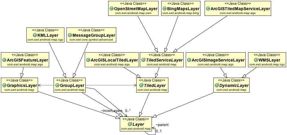
 Known Direct Subclasses Known Direct Subclasses
|
|
Known Indirect Subclasses
|

Class Overview
The base layer for all layers that can be added into MapView.
Developer Guides
For more information about map layer types, read the Layer developer guide.
Summary
| Fields | |||||||||||
|---|---|---|---|---|---|---|---|---|---|---|---|
| protected UserCredentials | credentials | Gets the direct access of the credentials; You can access the credentials by the getCredentials() or
setCredentials(UserCredentials); but those two methods copy the instance internally. |
|||||||||
| protected long | nativeHandle | ||||||||||
| protected Map<Integer, ArcGISPopupInfo> | popUpInfos | ||||||||||
| protected Object | serviceInfo | ||||||||||
| Public Constructors | |||||||||||
|---|---|---|---|---|---|---|---|---|---|---|---|
|
Layer()
Instantiates an object of Layer.
| |||||||||||
| Protected Constructors | |||||||||||
|---|---|---|---|---|---|---|---|---|---|---|---|
| Layer(boolean initLayer) | |||||||||||
|
Layer(long handle)
Instantiates an object of Layer.
| |||||||||||
| Public Methods | |||||||||||
|---|---|---|---|---|---|---|---|---|---|---|---|
| Popup |
createPopup(MapView mapView, int sublayerId, Graphic graphic)
Creates the popup.
| ||||||||||
| UserCredentials |
getCredentials()
Gets a copy of the credentials attached to the Layer.
| ||||||||||
| SpatialReference |
getDefaultSpatialReference()
Gets the defaultSpatialReference of the Layer.
| ||||||||||
| Polygon |
getExtent()
Gets the current extent.
| ||||||||||
| Envelope |
getFullExtent()
Returns the full extent of the layer.
| ||||||||||
| int |
getHeight()
Gets the height of the Layer in screen units.
| ||||||||||
| long |
getID()
Return the Layer runtime ID which is a long integer.
| ||||||||||
| double |
getMaxScale()
Gets max scale.
| ||||||||||
| double |
getMinScale()
Gets min scale.
| ||||||||||
| String |
getName()
Gets the name of the layer.
| ||||||||||
| float |
getOpacity()
Gets the opacity of the Layer.
| ||||||||||
| Layer |
getParent()
Returns parent layer if the layer is in a group layer otherwise returning null.
| ||||||||||
| ArcGISPopupInfo |
getPopupInfo(int sublayerId)
Gets the
PopupInfo associated with the sub-layer id. | ||||||||||
| Map<Integer, ArcGISPopupInfo> |
getPopupInfos()
Gets the popup infos.
| ||||||||||
| String |
getQueryUrl(int subLayerId)
Gets the query url.
| ||||||||||
| double |
getResolution()
Gets the resolution of the Layer.
| ||||||||||
| SpatialReference |
getSpatialReference()
Gets the current spatial reference of the Layer.
| ||||||||||
| String |
getTitle()
Gets the title of the Layer.
| ||||||||||
| String |
getUrl()
Gets the URL of the map service associated with the layer.
| ||||||||||
| int |
getUrlHashCode()
A convenience method that returns the hash code of the map service URL.
| ||||||||||
| String |
getWebMapLayerID()
Gets the web map layer id.
| ||||||||||
| int |
getWidth()
Gets the width of the Layer in screen units.
| ||||||||||
| boolean |
isInitialized()
Gets the initialized of the Layer.
| ||||||||||
| boolean |
isRecycled()
Returns true or false if the Layer object has been recycled.
| ||||||||||
| boolean |
isShowLegend()
Returns true if legend of the layer will be shown up; by default it is true; The property is usually defined in the
web map, a operation layer legend could be on or off.
| ||||||||||
| boolean |
isVisible()
Gets the visibility of the Layer.
| ||||||||||
| boolean |
isWebMapBaselayer()
Returns true if the layer is used as base layer in a web map.
| ||||||||||
| void |
recycle()
Releases resources referenced by the Layer so that they can be recycled.
| ||||||||||
| void |
reinitializeLayer(UserCredentials usercredentials)
Re-initializes the layer with the given credentials.
| ||||||||||
| void |
setMaxScale(double maxScale)
Sets max scale.
| ||||||||||
| void |
setMinScale(double minScale)
Sets min scale.
| ||||||||||
| void |
setName(String name)
Sets the layer name.
| ||||||||||
| void |
setOnStatusChangedListener(OnStatusChangedListener onStatusChangedListener)
Sets the onStatusChangedListener.
| ||||||||||
| void |
setOpacity(float opacity)
Sets the opacity of the Layer.
| ||||||||||
| void |
setPopupInfos(Map<Integer, ArcGISPopupInfo> popUpInfos)
Sets the popup infos.
| ||||||||||
| void |
setQueryUrls(Map<Integer, String> queryUrls)
Sets the query urls.
| ||||||||||
| void |
setVisible(boolean visible)
Sets the visibility of the Layer.
| ||||||||||
| Protected Methods | |||||||||||
|---|---|---|---|---|---|---|---|---|---|---|---|
| void |
changeStatus(OnStatusChangedListener.STATUS status)
Changes the STATUS of the layer and notifies the listener.
| ||||||||||
| abstract long | create() | ||||||||||
| void | finalize() | ||||||||||
| float | getDpi() | ||||||||||
| Envelope |
getInitialExtent()
Returns the initial extent of the layer.
| ||||||||||
| ExecutorService |
getPoolExecutor()
Returns the ThreadPoolExecutor based on the context.
| ||||||||||
| ExecutorService |
getServiceExecutor()
Returns the ThreadPoolExecutor based on the context.
| ||||||||||
| abstract void |
initLayer()
Initializes the layer.
| ||||||||||
| void |
initializeMinMaxScale(double initalMinScale, double initalMaxScale)
honor the webmaplayer min/max scale first, if it is not override, then using service min/max if they are set.
| ||||||||||
| <T> T |
loadServiceInfo(Callable<T> task)
If the Layer is loaded as a WebMapLayer and the OnWebMapLoadListener is specified, the service information will be
loaded interactively.
| ||||||||||
| synchronized long | lock() | ||||||||||
| void |
setCredentials(UserCredentials credentials)
Sets the credentials of the Layer.
| ||||||||||
| void |
setDefaultSpatialReference(SpatialReference defaultSpatialReference)
Sets the defaultSpatialReference of the Layer.
| ||||||||||
| void | setFullExtent(Envelope extent) | ||||||||||
| void |
setInitialExtent(Envelope e)
Sets the initial extent of layer.
| ||||||||||
| void |
setUrl(String url)
Sets the URL of the map service associated with the layer.
| ||||||||||
| void | unlock(long handle) | ||||||||||
| void |
updateSpatialReferenceStatus(int SRStatus)
The callback method is invoked when the layer is added to map.
| ||||||||||
| boolean |
verifyCredentials()
Returns true if the credentials is valid.
| ||||||||||
|
[Expand]
Inherited Methods | |||||||||||
|---|---|---|---|---|---|---|---|---|---|---|---|
|
From class
java.lang.Object
| |||||||||||
Fields
protected UserCredentials credentials
Gets the direct access of the credentials; You can access the credentials by the getCredentials() or
setCredentials(UserCredentials); but those two methods copy the instance internally.
protected long nativeHandle
Public Constructors
public Layer ()
Instantiates an object of Layer.
Protected Constructors
protected Layer (boolean initLayer)
protected Layer (long handle)
Instantiates an object of Layer.
Public Methods
public Popup createPopup (MapView mapView, int sublayerId, Graphic graphic)
Creates the popup.
Parameters
| mapView | the map view |
|---|---|
| sublayerId | the sublayer id |
| graphic | the graphic |
Returns
- the popup
public UserCredentials getCredentials ()
Gets a copy of the credentials attached to the Layer.
Returns
- Returns the credentials.
public SpatialReference getDefaultSpatialReference ()
Gets the defaultSpatialReference of the Layer.
Returns
- Returns the defaultSpatialReference.
public Polygon getExtent ()
Gets the current extent.
Returns
- a polygon which represents the current extent.
public Envelope getFullExtent ()
Returns the full extent of the layer. Returns NULL if the layer does not have a full extent.
Returns
- an Envelope object
public int getHeight ()
Gets the height of the Layer in screen units.
Returns
- height.
public long getID ()
Return the Layer runtime ID which is a long integer. A zero will be returned if the Layer object is invalid.
Returns
- a long integer.
public double getMaxScale ()
Gets max scale. When map zooms in beyond max scale, graphics are not visible.
Returns
- max scale.
public double getMinScale ()
Gets min scale. When map zooms out beyond min scale, graphics are not visible.
Returns
- min scale
public String getName ()
Gets the name of the layer. The name is the name of the service if the layer is associated with a service, otherwise it is null. You should not call this method until the layer is initialized.
Returns
- the name of the associated service or null otherwise.
public float getOpacity ()
Gets the opacity of the Layer.
Returns
- the opacity.
public Layer getParent ()
Returns parent layer if the layer is in a group layer otherwise returning null.
Returns
- Layer a Layer object
public ArcGISPopupInfo getPopupInfo (int sublayerId)
public String getQueryUrl (int subLayerId)
Gets the query url.
Parameters
| subLayerId | the sub layer id |
|---|
Returns
- the queryUrl for the sub-layer ID
public double getResolution ()
Gets the resolution of the Layer.
Returns
- resolution.
public SpatialReference getSpatialReference ()
Gets the current spatial reference of the Layer.
Returns
- spatial reference.
public String getTitle ()
Gets the title of the Layer. WebMap may define title of a layer, when the layer is instantiated from a WebMap, it may have a tile.
Returns
- Returns the title.
public String getUrl ()
Gets the URL of the map service associated with the layer.
Returns
- the URL as a string.
public int getUrlHashCode ()
A convenience method that returns the hash code of the map service URL. The hash codes for map service URLs are cached and this method spares the effort of the developer programmatically calculating the hash code.
Returns
- integer of the hashcode
public int getWidth ()
Gets the width of the Layer in screen units.
Returns
- width.
public boolean isInitialized ()
Gets the initialized of the Layer.
Returns
- Returns the initialized.
public boolean isRecycled ()
Returns true or false if the Layer object has been recycled.
Returns
- boolean
public boolean isShowLegend ()
Returns true if legend of the layer will be shown up; by default it is true; The property is usually defined in the web map, a operation layer legend could be on or off.
Returns
- boolean
public boolean isVisible ()
Gets the visibility of the Layer.
Returns
- true if visible.
public boolean isWebMapBaselayer ()
Returns true if the layer is used as base layer in a web map.
Returns
- boolean
public void recycle ()
Releases resources referenced by the Layer so that they can be recycled.
public void reinitializeLayer (UserCredentials usercredentials)
Re-initializes the layer with the given credentials.
Parameters
| usercredentials | the new credentials to try. |
|---|
public void setMaxScale (double maxScale)
Sets max scale.
Parameters
| maxScale | max scale. |
|---|
public void setMinScale (double minScale)
Sets min scale.
Parameters
| minScale | min scale. |
|---|
public void setOnStatusChangedListener (OnStatusChangedListener onStatusChangedListener)
Sets the onStatusChangedListener. When initialize a Layer, the OnStatusChangedListener notifies you the status
changes for INITIALIZED or INITIALIZATION_FAILED. When the initialization is failed,
you can use the getError() to get the error details.
Parameters
| onStatusChangedListener | The onStatusChangedListener to set. |
|---|
public void setOpacity (float opacity)
Sets the opacity of the Layer.
Parameters
| opacity | the opacity to set. |
|---|
public void setPopupInfos (Map<Integer, ArcGISPopupInfo> popUpInfos)
Sets the popup infos.
Parameters
| popUpInfos | the popup infos |
|---|
public void setQueryUrls (Map<Integer, String> queryUrls)
Sets the query urls.
Parameters
| queryUrls | the query urls |
|---|
public void setVisible (boolean visible)
Sets the visibility of the Layer.
Parameters
| visible | The visibility to set. |
|---|
Protected Methods
protected void changeStatus (OnStatusChangedListener.STATUS status)
Changes the STATUS of the layer and notifies the listener.
Parameters
| status | the new STATUS. |
|---|
protected abstract long create ()
protected float getDpi ()
protected Envelope getInitialExtent ()
Returns the initial extent of the layer. Returns the full extent if the initial extent is not valid.
Returns
- an Envelope object
protected ExecutorService getServiceExecutor ()
Returns the ThreadPoolExecutor based on the context.
protected abstract void initLayer ()
Initializes the layer. The implementation should submit the OnStatusChangedListener.STATUS event accordingly.
protected void initializeMinMaxScale (double initalMinScale, double initalMaxScale)
honor the webmaplayer min/max scale first, if it is not override, then using service min/max if they are set.
Parameters
| initalMinScale | - min scale of service. |
|---|---|
| initalMaxScale | - max scale of service. |
protected T loadServiceInfo (Callable<T> task)
If the Layer is loaded as a WebMapLayer and the OnWebMapLoadListener is specified, the service information will be loaded interactively.
Parameters
| task | the Task to load the service information. |
|---|
Returns
- the service information.
Throws
| Exception |
|---|
protected synchronized long lock ()
protected void setCredentials (UserCredentials credentials)
Sets the credentials of the Layer. The layer holds the copy of the given instance.
Parameters
| credentials | The credentials to set. |
|---|
protected void setDefaultSpatialReference (SpatialReference defaultSpatialReference)
Sets the defaultSpatialReference of the Layer.
Parameters
| defaultSpatialReference | The defaultSpatialReference to set. |
|---|
protected void setInitialExtent (Envelope e)
Sets the initial extent of layer.
Parameters
| e | --an Envelope object. |
|---|
protected void setUrl (String url)
Sets the URL of the map service associated with the layer.
Parameters
| url | the URL pointing to your map service. |
|---|
protected void unlock (long handle)
protected void updateSpatialReferenceStatus (int SRStatus)
The callback method is invoked when the layer is added to map. 0 - Spatial Reference Invalid 1 - Spatial Reference NotNeeded 2 - Spatial Reference Projected 3 - Spatial Reference Good
Parameters
| SRStatus | an integer indicating the spatial reference status of layer |
|---|
protected boolean verifyCredentials ()
Returns true if the credentials is valid.