Description
When parent element is ArcPad, MAP is used in ArcPad map files (*.apm) to define maps.
Diagram
Overview
 |
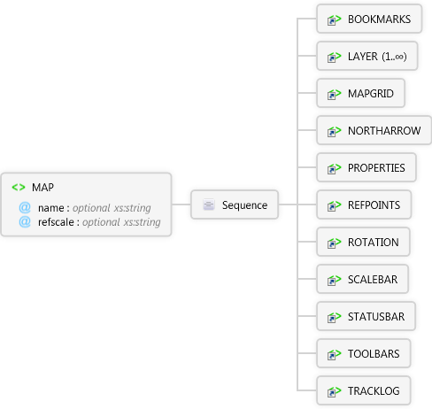
MAP
When parent element is ArcPad, MAP is used in ArcPad map files (*.apm) to define maps.
 |
name optional xs:string
The name of the map.
|
|
refscale optional xs:string
Reference scale to display the symbology for all layers in the map. The scale is specfied using a relative scale such as 1:24000. Symbols are scaled relative to the refscale as the map is zoomed in or out.
|
 |
Sequence
 |
BOOKMARKS
The parent element for setting bookmarks.
|
|
LAYER 1..∞
When used in a map file (*.apm), it defines the characteristics of one of the map layers.
|
|
MAPGRID
Used to specify map grid settings in ArcPadPrefs.apx. Also specifies map grid visibility in an ArcMap map file (*.apm).Used to specify map grid settings in ArcPadPrefs.apx. Also specifies map grid visibility in an ArcMap map file (*.apm).
|
|
NORTHARROW
Used to define display properties for the north arrow in an ArcPad map file (*.apm).
|
|
PROPERTIES
Defines properties for the map in an ArcPad map file (*.apm).
|
|
REFPOINTS
User to specify reference points in a map for use with the offset and traverse tools.
|
|
ROTATION
Used to define rotation properties for the map in an ArcPad map file (*.apm).
|
|
SCALEBAR
Used to define display properties for the scalebar in an ArcPad map file (*.apm).
|
|
STATUSBAR
Used to define display properties for the status bar.
|
|
TOOLBARS
The parent element for all ArcPad toolbars.
|
|
TRACKLOG
Used to specify the GPS tracklog settings in ArcPadPrefs.apx. Also specifies tracklog visibility in an ArcMap map file (*.apm).
|
|
|
Attributes
| Name | Type | Use | Default | Fixed | Description |
|---|
| name | xs:string | optional | | | The name of the map. |
| refscale | xs:string | optional | | | Reference scale to display the symbology for all layers in the map. The scale is specfied using a relative scale such as 1:24000. Symbols are scaled relative to the refscale as the map is zoomed in or out. |
Remarks
Examples
Source
<xs:element name="MAP" xmlns:xs="http://www.w3.org/2001/XMLSchema">
  <xs:annotation>
    <xs:documentation>When parent element is ArcPad, MAP is used in ArcPad map files (*.apm) to define maps.</xs:documentation>
  </xs:annotation>
  <xs:complexType>
    <xs:sequence>
      <xs:element ref="apm:BOOKMARKS" />
      <xs:element maxOccurs="unbounded" ref="apm:LAYER" />
      <xs:element ref="apm:MAPGRID" />
      <xs:element ref="apm:NORTHARROW" />
      <xs:element ref="apm:PROPERTIES" />
      <xs:element ref="apm:REFPOINTS" />
      <xs:element ref="apm:ROTATION" />
      <xs:element ref="apm:SCALEBAR" />
      <xs:element ref="apm:STATUSBAR">
        <xs:annotation>
          <xs:documentation>Used to define display properties for the status bar.</xs:documentation>
        </xs:annotation>
      </xs:element>
      <xs:element ref="apm:TOOLBARS" />
      <xs:element ref="apm:TRACKLOG" />
    </xs:sequence>
    <xs:attribute name="name" type="xs:string">
      <xs:annotation>
        <xs:documentation>The name of the map.</xs:documentation>
      </xs:annotation>
    </xs:attribute>
    <xs:attribute name="refscale" type="xs:string">
      <xs:annotation>
        <xs:documentation>Reference scale to display the symbology for all layers in the map. The scale is specfied using a relative scale such as 1:24000. Symbols are scaled relative to the refscale as the map is zoomed in or out.</xs:documentation>
      </xs:annotation>
    </xs:attribute>
  </xs:complexType>
</xs:element> |
See Also