


 Syntax
| Visual Basic (Declaration) | |
|---|---|
Public Property Gradient As LinearGradientBrush | |
| C# | |
|---|---|
public LinearGradientBrush Gradient {get; set;} | |
Remarks
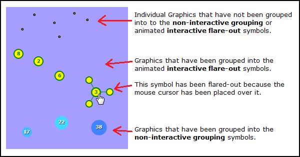
The FlareClusterer allows users to view geographic phenomena in a condensed form by clustering the number of occurrences of features into non-interactive grouping and animated interactive flare-out symbols. The FlareClusterer can be used on features in a FeatureLayer or GraphicsLayer. The following is a visual depiction of various style of graphics that can be displayed using the FlareClusterer:
Use the FlareClusterer.Gradient Property to ramp colors between the non-interactive grouping symbols. The FlareClusterer.Gradient Property is set to a System.Windows.Media.LinearGradientBrush. The System.Windows.Media.LinearGradientBrush is made up of a System.Windows.Media.GradientStopCollection which is a container for System.Windows.Media.GradientStop objects. Each System.Windows.Media.GradientStop object has a .Color and .Offset Property which is used to define a specific color in the color ramp.
The System.Windows.Media.GradientStop with the smallest .Offset value becomes one end of the color ramp. The System.Windows.Media.GradientStop with the largest .Offset value becomes the other end of the color ramp. The .Color values are ramped along the color wheel continuum between the two .Offset values. Interim System.Windows.Media.GradientStop objects can be added in-between the two ends of colors and ramped along the color wheel continuum between the stops. See the following diagram:
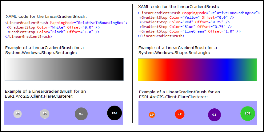
If the System.Windows.Media.GradientBrush.MappingMode is set to Absolute, the offsets correspond to the number of elements in that cluster. If set to RelativeToBoundingBox, offsets should be specified from 0..1, and will be relative to the largest cluster at the current specific scale.
Property Value
The gradient.Requirements
Target Platforms: Windows XP Professional, Windows Server 2003 family, Windows Vista, Windows Server 2008 family, Windows 7