| Visual Basic (Declaration) | |
|---|---|
Public MustInherit Class DataSource | |
| C# | |
|---|---|
public abstract class DataSource | |
Dynamic Layers allow the execution of various ArcGIS Server requests from a client application. An in-depth discussion about Dynamic Layers is in the ArcGISDynamicMapServiceLayer Class documentation. The client side requests that can be issued to ArcGIS Server include the ability to:
- Change the rendering of an existing ArcGISDynamicMapServiceLayer. See the code examples for the ArcGISDynamicMapServiceLayer.LayerDrawingOptions Property, the ArcGISDynamicMapServiceLayer.CreateDynamicLayerInfosFromLayerInfos Method, and the LayerDrawingOptionsCollection Class.
- Create a layer on-the-fly for the Workspace Types of: Database, Shapefile, FileGDB, and Raster. See the code examples in the ArcGISDynamicMapServiceLayer.DynamicLayerInfos Property and the DynamicLayerInfoCollection Class.
- Perform table joins.
- Query for specific records. See the code example for the QueryDataSource Class.
- Identify features. See the code example for the Tasks.IdentifyParameters.DynamicLayerInfos Property.
- Return raster images.
Dynamic Layers are new in ArcGIS Server v10.1 and require the ArcGIS API 3.0 for Silverlight and higher.
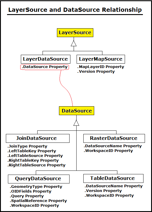
Use one of the four inherited DataSource Classes to utilize a Dynamic Layer:
The LayerDataSource.DataSource Property accepts the DataSource object.
The following image is simplified Object Model Diagram demonstrating the relationship between the LayerSource and DataSource objects in constructing a Dynamic Layer.

System.Object
ESRI.ArcGIS.Client.DataSource
ESRI.ArcGIS.Client.JoinDataSource
ESRI.ArcGIS.Client.QueryDataSource
ESRI.ArcGIS.Client.RasterDataSource
ESRI.ArcGIS.Client.TableDataSource
Target Platforms: Windows XP Professional, Windows Server 2003 family, Windows Vista, Windows Server 2008 family, Windows 7


