


 Syntax
| Visual Basic (Declaration) | |
|---|---|
Public Sub GetDetails( _ ByVal id As Integer, _ ByVal onCompleted As Action(Of FeatureLayerInfo,Exception) _ ) | |
| C# | |
|---|---|
public void GetDetails( int id, Action<FeatureLayerInfo,Exception> onCompleted ) | |
Remarks
The GetDetails Method returns a FeatureLayerInfo object for a specific sub-layer ID. The FeatureLayerInfo object is rich with numerous Properties that can be used to get metadata information about the ArcGISDynamicMapServiceLayer web service. To get the details for all sub-layers in an ArcGISDynamicMapServiceLayer consider using the ArcGISDynamicMapServiceLayer.GetAllDetails instead.
For most ArcGISDynamicMapServiceLayer Properties that have both get/set (C#) or Read/Write (VB.NET) Properties, accessing the get/Read for a particular Property will return null/Nothing from ArcGIS Server. The exceptions are DisableClientCaching which returns false and ImageFormat which returns ESRI.ArcGIS.Client.ArcGISDynamicMapServiceLayer.RestImageFormat.PNG32; these are the default values. For all other get/set (C#) or Read/Write (VB.NET) Property values, in order to obtain get/Read information the application developer must first set/Write the values. Use the various ArcGISDynamicMapServiceLayer Methods to serve as a starting point to obtain ArcGIS Server metadata information for the set/Write Properties.
Parameters
- id
- The sub-layer or table id.
- onCompleted
- The method to call when details of the sub-layer or table is retrieved.
Example
How to use:
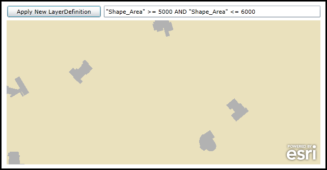
When the application loads an ArcGISDynamicMapServiceLayer will display. One of the sub-layers has a LayerDefinition value specified which restrict how many features are returned in the Map. Click your cursor in the TextBox for the sub-layer LayerDefinition and modify it. Then click the Button to see the changes. If you type a bogus LayerDefintion in the TextBox for the sub-layer, it will not display. Use the "1=1" to return all features for the sub-layer.
The XAML code in this example is used in conjunction with the code-behind (C# or VB.NET) to demonstrate the functionality.
The following screen shot corresponds to the code example in this page.
| XAML |  Copy Code Copy Code |
|---|---|
<Grid x:Name="LayoutRoot"> <!-- Add a Map Control and zoom into an area of interest that shows useful information. --> <esri:Map Background="White" HorizontalAlignment="Left" Margin="7,311,0,0" Name="Map1" VerticalAlignment="Top" Height="283" Width="616" Extent="13414332,392041,13415767,392701"> <!-- Add an ArcGISDynamicMapServiceLayer. Wire up an Initialized Event to give back the LayerDefinition for a specific sub-layer that users can tweak to modify the results.--> <esri:ArcGISDynamicMapServiceLayer ID="MyUniqueName" Url="http://sampleserver3.arcgisonline.com/ArcGIS/rest/services/BloomfieldHillsMichigan/Parcels/MapServer" Initialized="ArcGISDynamicMapServiceLayer_Initialized" /> </esri:Map> <!-- Add a Button to apply to modify ArcGISDynamicMapServiceLayer.LayerDefinitions. --> <Button Content="Apply New LayerDefinition" Height="23" HorizontalAlignment="Left" Margin="7,282,0,0" Name="Button_ApplyNewLayerDefinition" VerticalAlignment="Top" Width="184" Click="Button_ApplyNewLayerDefinition_Click"/> <TextBox Height="23" HorizontalAlignment="Left" Margin="206,282,0,0" Name="TextBox1" VerticalAlignment="Top" Width="417" /> <!-- Provide the instructions on how to use the sample code. --> <TextBlock Height="102" HorizontalAlignment="Left" Name="TextBlock1" VerticalAlignment="Top" Width="756" TextWrapping="Wrap" Text="When the application loads an ArcGISDynamicMapServiceLayer will display. One of the sub-layers has a LayerDefinition value specified which restrict how many features are returned in the Map. Click your cursor in the TextBox for the sub-layer LayerDefinition and modify it. Then click the Button to see the changes. If you type a bogus LayerDefintion in the TextBox for the sub-layer, it will not display. Use the '1=1' to return all features for the sub-layer." /> </Grid> | |
| C# | Copy Code |
|---|---|
private void ArcGISDynamicMapServiceLayer_Initialized(object sender, System.EventArgs e) { // When the ArcGISDynamicMapServiceLayer Initializes get the LayerDefinition expression for a specific sub-layer. // It is necessary to use the ArcGISDynamicMapServiceLayer.GetDetails Method to obtain the LayerDefintion // for the sub-layer of the web service on ArcGIS Server. // NOTE: You can not use the ArcGISDynamicMapServiceLayer.LayerDefinitions Property to obtain these values as // this the Property will always return null/Nothing. // Get the ArcGISDynamicMapServiceLayer from the Map Control by its ID value that was set in XAML. ESRI.ArcGIS.Client.ArcGISDynamicMapServiceLayer myArcGISDynamicMapServiceLayer = (ESRI.ArcGIS.Client.ArcGISDynamicMapServiceLayer)(Map1.Layers["MyUniqueName"]); // Get the details for the first (i.e. 0) sub-layer and display it's DefinitionExpression in the TextBox. myArcGISDynamicMapServiceLayer.GetDetails(0, (ESRI.ArcGIS.Client.FeatureService.FeatureLayerInfo myFeatureLayerInfo, Exception myException) => { if (myException == null) { TextBox1.Text = myFeatureLayerInfo.DefinitionExpression; } }); } private void Button_ApplyNewLayerDefinition_Click(object sender, System.Windows.RoutedEventArgs e) { // This function will apply the user changes to the sub-layer LayerDefintion to produce a new map // with different features returned. // Get the ArcGISDynamicMapServiceLayer from the Map Control by its ID value that was set in XAML. ESRI.ArcGIS.Client.ArcGISDynamicMapServiceLayer myArcGISDynamicMapServiceLayer = (ESRI.ArcGIS.Client.ArcGISDynamicMapServiceLayer)(Map1.Layers["MyUniqueName"]); // Create an ObservableCollection of sub-layer LayerDefinitions. System.Collections.ObjectModel.ObservableCollection<ESRI.ArcGIS.Client.LayerDefinition> myObservableCollection = new System.Collections.ObjectModel.ObservableCollection<ESRI.ArcGIS.Client.LayerDefinition>(); // Create a new LayerDefinition object for the first (i.e. 0) sub-layer. Set the ID and Definition values. ESRI.ArcGIS.Client.LayerDefinition myDefinition = new ESRI.ArcGIS.Client.LayerDefinition(); myDefinition.LayerID = 0; myDefinition.Definition = TextBox1.Text; myObservableCollection.Add(myDefinition); // Apply the custom LayerDefinition to the ArcGISDynamicMapServiceLayer. myArcGISDynamicMapServiceLayer.LayerDefinitions = myObservableCollection; // Need to invoke the Refresh Method to redraw the sub-layer in the ArcGISDynamicMapServiceLayer. myArcGISDynamicMapServiceLayer.Refresh(); } | |
| VB.NET | Copy Code |
|---|---|
Private Sub ArcGISDynamicMapServiceLayer_Initialized(ByVal sender As System.Object, ByVal e As System.EventArgs) ' When the ArcGISDynamicMapServiceLayer Initializes get the LayerDefinition expression for a specific sub-layer. ' It is necessary to use the ArcGISDynamicMapServiceLayer.GetDetails Method to obtain the LayerDefintion ' for the sub-layer of the web service on ArcGIS Server. ' NOTE: You can not use the ArcGISDynamicMapServiceLayer.LayerDefinitions Property to obtain these values as ' this the Property will always return null/Nothing. ' Get the ArcGISDynamicMapServiceLayer from the Map Control by its ID value that was set in XAML. Dim myArcGISDynamicMapServiceLayer As ESRI.ArcGIS.Client.ArcGISDynamicMapServiceLayer = CType(Map1.Layers("MyUniqueName"), ESRI.ArcGIS.Client.ArcGISDynamicMapServiceLayer) ' Get the details for the first (i.e. 0) sub-layer and display it's DefinitionExpression in the TextBox. myArcGISDynamicMapServiceLayer.GetDetails(0, Sub(myFeatureLayerInfo As ESRI.ArcGIS.Client.FeatureService.FeatureLayerInfo, myException As Exception) If myException Is Nothing Then TextBox1.Text = myFeatureLayerInfo.DefinitionExpression End If End Sub) End Sub Private Sub Button_ApplyNewLayerDefinition_Click(sender As System.Object, e As System.Windows.RoutedEventArgs) ' This function will apply the user changes to the sub-layer LayerDefintion to produce a new map ' with different features returned. ' Get the ArcGISDynamicMapServiceLayer from the Map Control by its ID value that was set in XAML. Dim myArcGISDynamicMapServiceLayer As ESRI.ArcGIS.Client.ArcGISDynamicMapServiceLayer = CType(Map1.Layers("MyUniqueName"), ESRI.ArcGIS.Client.ArcGISDynamicMapServiceLayer) ' Create an ObservableCollection of sub-layer LayerDefinitions. Dim myObservableCollection As New System.Collections.ObjectModel.ObservableCollection(Of ESRI.ArcGIS.Client.LayerDefinition) ' Create a new LayerDefinition object for the first (i.e. 0) sub-layer. Set the ID and Definition values. Dim myDefinition As New ESRI.ArcGIS.Client.LayerDefinition myDefinition.LayerID = 0 myDefinition.Definition = TextBox1.Text myObservableCollection.Add(myDefinition) ' Apply the custom LayerDefinition to the ArcGISDynamicMapServiceLayer. myArcGISDynamicMapServiceLayer.LayerDefinitions = myObservableCollection ' Need to invoke the Refresh Method to redraw the sub-layer in the ArcGISDynamicMapServiceLayer. myArcGISDynamicMapServiceLayer.Refresh() End Sub | |
Requirements
Target Platforms: Windows XP Professional, Windows Server 2003 family, Windows Vista, Windows Server 2008 family, Windows 7