Description
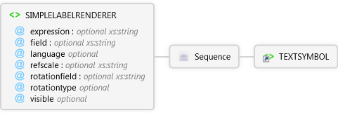
Used for labeling features. A field is specified for labeling all features of a particular layer.
Diagram
Overview
 |
SIMPLELABELRENDERER
Used for labeling features. A field is specified for labeling all features of a particular layer.
 |
expression optional xs:string
The VBScript or JScript expression that evaluates and formats the label. Shapefile fields must be surrounded by brackets ([]).
|
|
field optional xs:string
The field in the table that contains text for labeling features.
|
|
language optional Restriction of xs:string
The script engine that interprets the expression.
|
|
refscale optional xs:string
Reference scale to display the TEXTSYMBOL at the specified fontsize using a relative scale such as 1:24000. TEXTSYMBOLs are scaled relative to the refscale as the map is zoomed in or out.
|
|
rotationfield optional xs:string
The field in the table that contains the angle of rotation for a TEXTSYMBOL.
|
|
rotationtype optional Restriction of xs:string
Three methods of calculating angles are available: 1)"arithmetic", An angle of 0 is east, and angles are calculated counterclockwise from east. 2)"counterclockwise",An angle of 0 is north, and angles are calculated counterclockwise from north. 3)"geographic", An angle of 0 is north, and angles are calculated clockwise from north.
|
|
visible optional Restriction of xs:string
Flag that determines if the SIMPLELABELRENDER is visible in the map.
|
 |
Sequence
 |
TEXTSYMBOL
Symbol used to label point, line, and polygon layers.
|
|
|
Attributes
| Name | Type | Use | Default | Fixed | Description |
|---|
| expression | xs:string | optional | | | The VBScript or JScript expression that evaluates and formats the label. Shapefile fields must be surrounded by brackets ([]). |
| field | xs:string | optional | | | The field in the table that contains text for labeling features. |
| language | Restriction of xs:string | optional | VBScript | | The script engine that interprets the expression. |
| refscale | xs:string | optional | | | Reference scale to display the TEXTSYMBOL at the specified fontsize using a relative scale such as 1:24000. TEXTSYMBOLs are scaled relative to the refscale as the map is zoomed in or out. |
| rotationfield | xs:string | optional | | | The field in the table that contains the angle of rotation for a TEXTSYMBOL. |
| rotationtype | Restriction of xs:string | optional | | | Three methods of calculating angles are available: 1)"arithmetic", An angle of 0 is east, and angles are calculated counterclockwise from east. 2)"counterclockwise",An angle of 0 is north, and angles are calculated counterclockwise from north. 3)"geographic", An angle of 0 is north, and angles are calculated clockwise from north. |
| visible | Restriction of xs:string | optional | false | | Flag that determines if the SIMPLELABELRENDER is visible in the map. |
Examples
Restrictions
- One symbol must be specified. Only one is allowed.
- rotationfield and rotationtype can only be used in point shapefiles.
Source
<xs:element name="SIMPLELABELRENDERER" xmlns:xs="http://www.w3.org/2001/XMLSchema">
  <xs:annotation>
    <xs:documentation>Used for labeling features. A field is specified for labeling all features of a particular layer.</xs:documentation>
  </xs:annotation>
  <xs:complexType>
    <xs:sequence>
      <xs:element ref="apm:TEXTSYMBOL" />
    </xs:sequence>
    <xs:attribute name="expression" type="xs:string">
      <xs:annotation>
        <xs:documentation>The VBScript or JScript expression that evaluates and formats the label. Shapefile fields must be surrounded by brackets ([]). </xs:documentation>
      </xs:annotation>
    </xs:attribute>
    <xs:attribute name="field" type="xs:string">
      <xs:annotation>
        <xs:documentation>The field in the table that contains text for labeling features.</xs:documentation>
      </xs:annotation>
    </xs:attribute>
    <xs:attribute default="VBScript" name="language">
      <xs:annotation>
        <xs:documentation>The script engine that interprets the expression.</xs:documentation>
      </xs:annotation>
      <xs:simpleType>
        <xs:restriction base="xs:string">
          <xs:enumeration value="VBScript" />
          <xs:enumeration value="JScript" />
          <xs:enumeration value="Python" />
        </xs:restriction>
      </xs:simpleType>
    </xs:attribute>
    <xs:attribute name="refscale" type="xs:string">
      <xs:annotation>
        <xs:documentation>Reference scale to display the TEXTSYMBOL at the specified fontsize using a relative scale such as 1:24000. TEXTSYMBOLs are scaled relative to the refscale as the map is zoomed in or out.</xs:documentation>
      </xs:annotation>
    </xs:attribute>
    <xs:attribute name="rotationfield" type="xs:string">
      <xs:annotation>
        <xs:documentation>The field in the table that contains the angle of rotation for a TEXTSYMBOL.</xs:documentation>
      </xs:annotation>
    </xs:attribute>
    <xs:attribute name="rotationtype">
      <xs:annotation>
        <xs:documentation>Three methods of calculating angles are available: 1)"arithmetic", An angle of 0 is east, and angles are calculated counterclockwise from east. 2)"counterclockwise",An angle of 0 is north, and angles are calculated counterclockwise from north. 3)"geographic", An angle of 0 is north, and angles are calculated clockwise from north.</xs:documentation>
      </xs:annotation>
      <xs:simpleType>
        <xs:restriction base="xs:string">
          <xs:enumeration value="arithmetic" />
          <xs:enumeration value="counterclockwise" />
          <xs:enumeration value="geographic" />
        </xs:restriction>
      </xs:simpleType>
    </xs:attribute>
    <xs:attribute default="false" name="visible">
      <xs:annotation>
        <xs:documentation>Flag that determines if the SIMPLELABELRENDER is visible in the map.</xs:documentation>
      </xs:annotation>
      <xs:simpleType>
        <xs:restriction base="xs:string">
          <xs:enumeration value="true" />
          <xs:enumeration value="false" />
        </xs:restriction>
      </xs:simpleType>
    </xs:attribute>
  </xs:complexType>
</xs:element> |
See Also