 com.esri.arcgis.geoprocessing.AbstractGPTool
com.esri.arcgis.geoprocessing.tools.datamanagementtools.AggregatePolygons
com.esri.arcgis.geoprocessing.AbstractGPTool
com.esri.arcgis.geoprocessing.tools.datamanagementtools.AggregatePolygons
|
|||||||||
| PREV CLASS NEXT CLASS | FRAMES NO FRAMES | ||||||||
| SUMMARY: NESTED | FIELD | CONSTR | METHOD | DETAIL: FIELD | CONSTR | METHOD | ||||||||
java.lang.Object
public class AggregatePolygons
Combines polygons within a specified distance to each other into new polygons. The Aggregate Polygons tool is contained in the Data Management Tools tool box.
| Field Summary |
|---|
| Fields inherited from class com.esri.arcgis.geoprocessing.AbstractGPTool |
|---|
vals |
| Constructor Summary | |
|---|---|
AggregatePolygons()
Creates the Aggregate Polygons tool with defaults. |
|
AggregatePolygons(Object inFeatures,
                  Object outFeatureClass,
                  Object aggregationDistance)
Creates the Aggregate Polygons tool with the required parameters. |
|
| Method Summary | |
|---|---|
Object |
getAggregationDistance()
Returns the Aggregation Distance parameter of this tool . |
Object |
getInFeatures()
Returns the Input Features parameter of this tool . |
Object |
getMinimumArea()
Returns the Minimum Area parameter of this tool . |
Object |
getMinimumHoleSize()
Returns the Minimum Hole Size parameter of this tool . |
String |
getOrthogonalityOption()
Returns the Preserve orthogonal shape parameter of this tool . |
Object |
getOutFeatureClass()
Returns the Output Feature Class parameter of this tool . |
Object |
getOutTable()
Returns the Output Table parameter of this tool (Read only). |
String |
getToolboxAlias()
Returns the alias of the tool box containing this tool. |
String |
getToolboxName()
Returns the name of the tool box containing this tool. |
String |
getToolName()
Returns the name of this tool. |
void |
setAggregationDistance(Object aggregationDistance)
Sets the Aggregation Distance parameter of this tool . |
void |
setInFeatures(Object inFeatures)
Sets the Input Features parameter of this tool . |
void |
setMinimumArea(Object minimumArea)
Sets the Minimum Area parameter of this tool . |
void |
setMinimumHoleSize(Object minimumHoleSize)
Sets the Minimum Hole Size parameter of this tool . |
void |
setOrthogonalityOption(String orthogonalityOption)
Sets the Preserve orthogonal shape parameter of this tool . |
void |
setOutFeatureClass(Object outFeatureClass)
Sets the Output Feature Class parameter of this tool . |
| Methods inherited from class com.esri.arcgis.geoprocessing.AbstractGPTool |
|---|
getParameterValues, toString |
| Methods inherited from class java.lang.Object |
|---|
clone, equals, finalize, getClass, hashCode, notify, notifyAll, wait, wait, wait |
| Constructor Detail |
|---|
public AggregatePolygons()
Initializes the array of tool parameters with the default values specified when the tool was created.
public AggregatePolygons(Object inFeatures,
                         Object outFeatureClass,
                         Object aggregationDistance)
Initializes the array of tool parameters with the values as specified for the required parameters and with the default values for the other parameters.
inFeatures - Feature Layer, the polygon features to be aggregated.outFeatureClass - Feature Class, the output feature class to be created.aggregationDistance - Linear Unit, the distance to be satisfied between polygon boundaries for aggregation to happen. A distance must be specified, and it must be greater than zero. You can specify a preferred unit; the default is the feature unit.| Method Detail |
|---|
public Object getInFeatures()
public void setInFeatures(Object inFeatures)
inFeatures - Feature Layer, the polygon features to be aggregated.public Object getOutFeatureClass()
public void setOutFeatureClass(Object outFeatureClass)
outFeatureClass - Feature Class, the output feature class to be created.public Object getAggregationDistance()
public void setAggregationDistance(Object aggregationDistance)
aggregationDistance - Linear Unit, the distance to be satisfied between polygon boundaries for aggregation to happen. A distance must be specified, and it must be greater than zero. You can specify a preferred unit; the default is the feature unit.public Object getMinimumArea()
public void setMinimumArea(Object minimumArea)
minimumArea - Areal Unit, the minimum area for an aggregated polygon to be retained. The default value is zero, that is, to keep all polygons. You can specify a preferred unit; the default is the feature unit.public Object getMinimumHoleSize()
public void setMinimumHoleSize(Object minimumHoleSize)
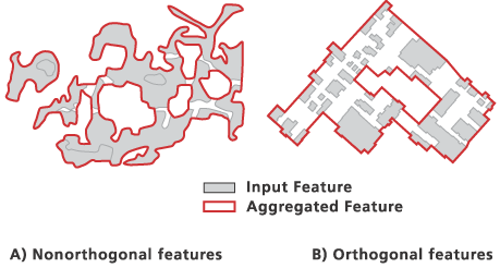
minimumHoleSize - Areal Unit, the minimum size of a polygon hole to be retained. The default value is zero, that is, to keep all polygon holes. You can specify a preferred unit; the default is the feature unit.public String getOrthogonalityOption()
public void setOrthogonalityOption(String orthogonalityOption)
orthogonalityOption - String, specifies the characteristic of the input features that will be preserved when constructing the aggregated boundaries.public Object getOutTable()
public String getToolName()
public String getToolboxName()
public String getToolboxAlias()
|
|||||||||
| PREV CLASS NEXT CLASS | FRAMES NO FRAMES | ||||||||
| SUMMARY: NESTED | FIELD | CONSTR | METHOD | DETAIL: FIELD | CONSTR | METHOD | ||||||||