What's new in Data Appliance 5.1 for ArcGIS
The Data Appliance 5.1 for ArcGIS has the following improvements and enhancements:
General
- The Data Appliance for ArcGIS contains only data and services that you are licensed to use. The Data collections overview provides information on the different collections and includes a table to help you understand the difference between the services in each collection.
- Cache is delivered in ArcGIS for Server 10.1 compact cache storage format providing for improved data storage and transfer. ArcGIS for Server 10.0 SP5 or higher is recommended to publish these services. For more information on compact cache, see the Inside the compact cache storage format topic in under Publishing services > Caching services > Map service caches in ArcGIS 10.1 for Server (Windows) Help or the Inside the compact cache storage format topic in ArcGIS for Server 10 .NET Help under Publishing services > Caching services > Map caches (2D).
- The services on the Data Appliance 5.1 for ArcGIS use a different directory structure than previous versions of the Data Appliance for ArcGIS. If you received a data collection update for the Data Appliance 5.1 for ArcGIS, ArcGIS services that utilize services from the Data Appliance 5.0 for ArcGIS or an earlier Data Appliance version must be deleted from ArcGIS Server before you disconnect the Data Appliance 5.0 or earlier version. See Deleting ArcGIS services on ArcGIS 10.0 or Deleting ArcGIS services on ArcGIS 10.1 for instructions on how to delete the services.
New Services
Three new services were added:
-
National Geographic World Map: The National Geographic basemap
provides a visually appealing map background. It is also suited as
a general reference map for many GIS projects. National Geographic
and Esri
collaborated to produce this cartographically distinctive basemap
that reflects National Geographic's cartographic design,
typographic style, and map policies.
World Light Gray Base and World Light Gray Reference: The World Light Gray Base and Reference maps are useful for adding your thematic content. The base provides a neutral background containing minimal colors, labels and features. Its reference layer sits on top of your thematic layers, providing geographic context and allowing your data to come to the foreground.
The base and reference maps include boundaries, city labels and urban areas, and major roads worldwide. Detailed coverage in North America, Europe, Southern Africa, South America, and Australia is designed to be consistent with the World Street Map and World Topographic Map. At all scales, user-added polygons, lines and point locations tend to be clearly visible on the light gray canvas basemap.

Updated data
The following basemaps and reference maps were updated:
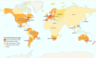
The World Imagery service includes updated high-resolution imagery throughout the world. Detailed information is available in the World Imagery service description and in the associated metadata layer provided with your source documents.
See the World Imagery 5.1 coverage map for more information on the updates and compare it to the World Imagery 5.0 coverage map.
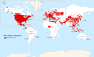
World Imagery 5.1 coverage map
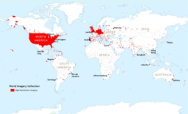
World Imagery 5.0 coverage map
The World Street Map basemap was updated worldwide. The following reference layers were also updated with similar coverage: World Boundaries and Places, World Boundaries and Places Alternate, and World Transportation. Detailed information is available in the service descriptions and in the associated metadata layers provided with your source documents.
See the World Street Map 5.1 coverage map for more information on the updates and compare it to the World Street Map 5.0 coverage map.
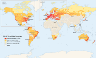
World Street Map 5.1 coverage map
World Street Map 5.0 coverage map
The World Topographic Map was updated. Detailed information is available in the service description and in the associated metadata layer provided with your source documents.
See the World Topographic Map 5.1 coverage map for more information on updates and compare it to the World Topographic Map 5.0 coverage map.
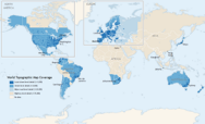
World Topographic Map 5.1 coverage map
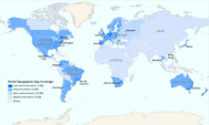
World Topographic Map 5.0 coverage map
Retired Data
- The World Navigation Charts map service was retired; this service is not included in the Data Appliance 5.1 for ArcGIS release.
- North America and Europe geocode and routing data and services from Data Appliance 5.0 for ArcGIS are no longer included as part of the Data Appliance 5.1 for ArcGIS release. If you are using North America and Europe geocode and routing services from Data Appliance 5.0 for ArcGIS or an earlier Data Appliance version, you need to migrate to StreetMap Premium for ArcGIS for your regions of interest prior to upgrading to Data Appliance 5.1 for ArcGIS.
World Places Locator DVD
If you were using the World Places Locator from Data Appliance 5.0 for ArcGIS or an earlier Data Appliance version, that geocoding service is no longer included as part of the data collection of drives. The locator is now shipped with Data Appliance 5.1 for ArcGIS on a separate DVD containing data, service documents, and help for publishing the World Places Locator. If you published the World Places Locator with a previous release, you need to update your environment to use the DVD version prior to your Data Appliance collection upgrade.