A container for specifying the parameters for building a geometric network.
Product Availability
Supported Platforms
Extended Error Information
Use the ISupportErrorInfo method InterfaceSupportsErrorInfo to determine if the object supports extended error information. If the object supports extended error info, VC++ developers should use the OLE/COM IErrorInfo interface to access the ErrorInfo object. Visual Basic developers should use the global error object Err to retrieve this extended error information.
Interfaces
| Interfaces | Description |
|---|---|
| INetworkLoader | Provides access to members used to create a new geometric network. |
| INetworkLoader2 | Provides access to members that specify parameters for creating a new geometric network. |
| INetworkLoader3 | Provides access to members that specify parameters for creating a new geometric network. |
| INetworkLoaderProps | Provides access to memebers that return the default names of fields and domains used by the network loader. |
| ISupportErrorInfo | Indicates whether a specific interface can return Automation error objects. |
Event Interfaces
| Interfaces | Description |
|---|---|
| INetworkLoaderProgress (default) | Provides access to events that occur when building a geometric network using a NetworkLoader object. |
To build a geometric network using the NetworkLoader object in C# you first need to create the object. Since INetworkLoader2 inherits from INetworkLoader, we can access the methods from both interfaces by declaring a single INetworkLoader2 variable.
INetworkLoader2 networkLoader2 = new NetworkLoaderClass() as INetworkLoader2;
At this point you can start specifying the parameters of how you want your geometric network built.
Feature Dataset Name
A geometric network is
built within a feature dataset. The NetworkLoader needs a reference
to the FeatureDatasetName object in
which you want to build the geometric network. The
featureDatasetName variable in the code below is a reference to the
IFeatureDatasetName
interface.
networkLoader2.FeatureDatasetName = featureDatasetName;
Network Name
You need to give your geometric network a name. The name of the
geometric network must be unique within the geodatabase. If you
only have one geometric network in your feature dataset you might
choose to give it the same name as that of the feature dataset.
networkLoader2.NetworkName = "water";
Type of Network
A network can be on of two types: utility or street. To build a
utility network you would specify the following:
networkLoader2.NetworkType = esriNTUtilityNetwork;
Snapping
When a geometric network is built, how the features are connected
is determined by their spatial relationship. As of the 10.0
release; snapping is specified at the geometric network level;
whichs that if used; all feature classes in your geometric network
will be snapped during creation.
Snap Tolerance
The snap tolerance controls
the search distance used for establishing connectivity during the
network building process. The snap tolerance is specified in map
units.
The following code shows you how to specify your snap tolerance as the value in the Double variable mySnapTol. Before setting the snap tolerance, it is best to check to make sure that the snap tolerance you propose is not less than the minimum snap tolerance in the MinSnapTolerance parameter.
if (mySnapTol < networkLoader2.MinSnapTolerance)
{
  Console.WriteLine("The proposed snap tolerance " + dMySnapTol +
                    " is less than the minimum snap tolerance of " +
                    networkLoader2.MinSnapTolerance + " for this feature dataset.");
  return;
}
networkLoader2.SnapTolerance = mySnapTol;
Adding Feature Classes
A geometric network is built from feature classes. These feature
classes must be contained within the feature dataset you specify.
There are a few restrictions on which feature classes you can use.
They must be either lines or points. They must not already be
participating in a geometric network. In the case of SDE, they must
not be registered as versioned. You can check for any of
these violations by calling the CanUseFeatureClass
method.
Please note that as of release 10.0, the CanChangeGeometry parameter is ignored; snapping is not specified at the feature class leve; but at the geometric network level with the INetworkLoader3.CanUseXYForSnapping.
networkLoader2.AddFeatureClass("FeatureClassName", esriFTSimple, null, isSnapped);
The NetworkLoader object can only build geometric networks with simple junction features, simple edge features, and complex edge features. You can look at the help for the INetworkFeature interfacefor more information on these types of features.
Adding Weights
You can also specify weights
to be added to your network. To learn more about weights see
the NetWeight object
help.
networkLoader2.AddWeight("WeightName", esriWeightType, BitGateSize);
For weights other than type esriWTBitGate, the
BitGateSize parameter should be set to zero.
Adding Weight Associations
The weights you specified for your network need to have values.
These values are taken from attributes of your feature
classes. Adding weight associations tells the network
which attributes belong to which weights. A weight can be
associated with multiple feature classes. These associations are
dependent on the type of field and the type of weight you created.
For example, a weight of type esriWTDouble can only be associated
with a field of type esriFieldTypeDouble. For weights of type
esriWTBitGate, the type of the field can be either
esriFieldTypeInteger or esriFieldTypeSmallInteger.
networkLoader2.AddWeightAssociation("WeightName", "FeatureClassName", "FieldName");
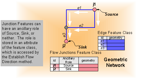
Ancillary Roles
You also need to specify which feature classes will have an
ancillary role. A feature class that you specify as having an
ancillary role means its features can either be sources or sinks
and it will determine flow in your network. The feature classes you
want to be built as having an ancillary role must be point feature
classes. Multiple feature classes in the network can have ancillary
roles. To do this, simply call the PutAncillaryRole
method for each feature class to have ancillary roles.
The field name you specify will contain the ancillary role attribute for this feature class. It is strongly recommended to use the default name for the ancillary role field. The default name for the ancillary role field can be obtained from the DefaultAncillaryRoleField property on the INetworkLoaderProps interface. If you specify an existing field to use as the ancillary role field, it is best to check that this field is of the correct type and domain can become an ancillary role field. You can check this by calling the CheckAncillaryRoleField method. If the field specified does not exist, then the NetworkLoader will automatically add it to the feature class when it builds the network, populating all values in this field with the value 0. The following code demonstrates using the default ancillary role field name and checking the ancillary role field before calling PutAncillaryRole:
INetworkLoaderProps networkLoaderProps = networkLoader2 as INetworkLoaderProps;
string defARFld = networkLoaderProps.DefaultAncillaryRoleField;
esriNetworkLoaderFieldCheck ckFld = networkLoader2.CheckAncillaryRoleField("FeatureClassName", defARFld);
switch (ckFld)
{
  case esriNLFCValid:
  case esriNLFCNotFound:
    networkLoader2.PutAncillaryRole("FeatureClassName", esriNCARSourceSink, defARFld);
    break;
  default:
    Console.WriteLine("The field " + defARFld + " could not be used as an ancillary role field.");
    return;
    break;
}
Enabled/Disabled Field
Every feature class
in your network must have a field that determines whether a feature
is enabled or disabled. Enabled and disabled features affect how
flow and the trace results are determined.
It is strongly recommended to use the default name for the enabled/disabled field. If you do not make a call to PutEnabledDisabledFieldName for a feature class, then the NetworkLoader assumes that you wish to use the default name for the enabled/disabled field. The default name for the enabled/disabled field can be obtained from the DefaultEnabledField property on the INetworkLoaderProps interface.
If you specify an existing field to use as the enabled/disabled field, it is best to check that this field is of the correct type and domain to be used as an enabled/disabled field. You can check this by calling the CheckEnabledDisabledField method. You also have the option of resetting all values in the existing field to True, or preserving the existing values. See the help for the PreserveEnabledValues property for more details.
If the field specified does not exist, then the NetworkLoader will automatically add it to the feature class when it builds the network, populating all values in this field with the value True. The following code demonstrates using the default enabled/disabled field name and checking the enabled/disabled field before calling PutEnabledDisabledFieldName (See the Note below). It also sets the PreserveEnabledValues property to True:
INetworkLoaderProps networkLoaderProps = pNetworkLoader2 as INetworkLoaderProps;
string defEDFld = networkLoaderProps.DefaultEnabledField;
esriNetworkLoaderFieldCheck ckFld = networkLoader2.CheckEnabledDisabledField("FeatureClassName", defEDFld);
switch(ckFld)
{
  case esriNLFCValid:
  case esriNLFCNotFound:
    networkLoader2.PutEnabledDisabledFieldName("FeatureClassName", "EnabledDisabledName");
    break;
  default:
    Console.WriteLine("The field " + defEDFld + " could not be used as an enabled/disabled field.");
    return;
    break;
}
networkLoader2.PreserveEnabledValues = true;
Note: In reality, this code (with exception to the call to PreserveEnabledValues) would not be necessary, since in the absence of calls to PutEnabledDisabledFieldName for a feature class, the NetworkLoader assumes that you wish to use the default enabled/disabled field for that feature class. The code is provided here for illustrative purposes.
Configuration Keyword
If you specified a
feature dataset that is a member of an SDE geodatabase, then you
may specify a configuration keyword for building your
geometric network. A configuration keyword is used to specify
storage and location parameters for optimal space and disk location
efficiency. The configuration keyword is provided by your database
administrator.
networkLoader2.ConfigurationKeyword = "myConfigKeyword";
Build Your Network
Finally, after specifying all of the parameters for your network
you need to tell the NetworkLoader object to build it. You can
do this by calling the LoadNetwork
method.
networkLoader2.LoadNetwork();
To build a geometric network using the NetworkLoader object in VB.NET you first need to create the object. Since INetworkLoader2 inherits from INetworkLoader, we can access the methods from both interfaces by declaring a single INetworkLoader2 variable.
Dim networkLoader2 As INetworkLoader2 = New NetworkLoader
At this point you can start specifying the parameters of how you want your geometric network built.
Feature Dataset Name
A geometric network is
built within a feature dataset. The NetworkLoader needs a reference
to the FeatureDatasetName object in
which you want to build the geometric network. The
featureDatasetName variable in the code below is a reference to the
IFeatureDatasetName
interface.
networkLoader2.FeatureDatasetName = featureDatasetName
Network Name
You need to give your geometric network a name. The name of the
geometric network must be unique within the geodatabase. If you
only have one geometric network in your feature dataset you might
choose to give it the same name as that of the feature dataset.
networkLoader2.NetworkName = "water"
Type of Network
A network can be on of two types: utility or street. To build a
utility network you would specify the following:
networkLoader2.NetworkType = esriNTUtilityNetwork
Snapping
When a geometric network is built, how the features are connected
is determined by their spatial relationship. As of the 10.0
release; snapping is specified at the geometric network level;
whichs that if used; all feature classes in your geometric network
will be snapped during creation.
Snap Tolerance
The snap tolerance controls
the search distance used for establishing connectivity during the
network building process. The snap tolerance is specified in map
units.
The following code shows you how to specify your snap tolerance as the value in the Double variable mySnapTol. Before setting the snap tolerance, it is best to check to make sure that the snap tolerance you propose is not less than the minimum snap tolerance in the MinSnapTolerance parameter.
If mySnapTol < networkLoader2.MinSnapTolerance Then
  Console.WriteLine("The proposed snap tolerance " & mySnapTol & _
                    " is less than the minimum snap tolerance of " & _
                    networkLoader2.MinSnapTolerance & " for this feature dataset.")
  Exit Sub
End If
networkLoader2.SnapTolerance = mySnapTol
Adding Feature Classes
A geometric network is built from feature classes. These feature
classes must be contained within the feature dataset you specify.
There are a few restrictions on which feature classes you can use.
They must be either lines or points. They must not already be
participating in a geometric network. In the case of SDE, they must
not be registered as versioned. You can check for any of
these violations by calling the CanUseFeatureClass
method.
Please note that as of release 10.0, the CanChangeGeometry parameter is ignored; snapping is not specified at the feature class leve; but at the geometric network level with the INetworkLoader3.CanUseXYForSnapping.
networkLoader2.AddFeatureClass("FeatureClassName", esriFTSimple, Nothing, isSnapped)
The NetworkLoader object can only build geometric networks with simple junction features, simple edge features, and complex edge features. You can look at the help for the INetworkFeature interface for more information on these types of features.
Adding Weights
You can also specify weights
to be added to your network. To learn more about weights see
the NetWeight object
help.
networkLoader2.AddWeight("WeightName", esriWeightType, BitGateSize)
For weights other than type esriWTBitGate, the
BitGateSize parameter should be set to zero.
Adding Weight Associations
The weights you specified for your network need to have values.
These values are taken from attributes of your feature
classes. Adding weight associations tells the network
which attributes belong to which weights. A weight can be
associated with multiple feature classes. These associations are
dependent on the type of field and the type of weight you created.
For example, a weight of type esriWTDouble can only be associated
with a field of type esriFieldTypeDouble. For weights of type
esriWTBitGate, the type of the field can be either
esriFieldTypeInteger or esriFieldTypeSmallInteger.
networkLoader2.AddWeightAssociation("WeightName", "FeatureClassName", "FieldName")
Ancillary Roles
You also need to specify which feature classes will have an
ancillary role. A feature class that you specify as having an
ancillary role means its features can either be sources or sinks
and it will determine flow in your network. The feature classes you
want to be built as having an ancillary role must be point feature
classes. Multiple feature classes in the network can have ancillary
roles. To do this, simply call the PutAncillaryRole
method for each feature class to have ancillary roles.
The field name you specify will contain the ancillary role attribute for this feature class. It is strongly recommended to use the default name for the ancillary role field. The default name for the ancillary role field can be obtained from the DefaultAncillaryRoleField property on the INetworkLoaderProps interface. If you specify an existing field to use as the ancillary role field, it is best to check that this field is of the correct type and domain can become an ancillary role field. You can check this by calling the CheckAncillaryRoleField method. If the field specified does not exist, then the NetworkLoader will automatically add it to the feature class when it builds the network, populating all values in this field with the value 0. The following code demonstrates using the default ancillary role field name and checking the ancillary role field before calling PutAncillaryRole:
Dim networkLoaderProps As INetworkLoaderProps = CType(networkLoader2, INetworkLoaderProps)
Dim defARFld As String = networkLoaderProps.DefaultAncillaryRoleField
Dim ckFld As esriNetworkLoaderFieldCheck = networkLoader2.CheckAncillaryRoleField("FeatureClassName", defARFld)
Select Case ckFld
  Case esriNLFCValid, esriNLFCNotFound
    networkLoader2.PutAncillaryRole("FeatureClassName", esriNCARSourceSink, defARFld)
  Case Else
    Console.WriteLine("The field " & defARFld & " could not be used as an ancillary role field.")
    Exit Sub
End Select
Enabled/Disabled Field
Every feature class
in your network must have a field that determines whether a feature
is enabled or disabled. Enabled and disabled features affect how
flow and the trace results are determined.
It is strongly recommended to use the default name for the enabled/disabled field. If you do not make a call to PutEnabledDisabledFieldName for a feature class, then the NetworkLoader assumes that you wish to use the default name for the enabled/disabled field. The default name for the enabled/disabled field can be obtained from the DefaultEnabledField property on the INetworkLoaderProps interface.
If you specify an existing field to use as the enabled/disabled field, it is best to check that this field is of the correct type and domain to be used as an enabled/disabled field. You can check this by calling the CheckEnabledDisabledField method. You also have the option of resetting all values in the existing field to True, or preserving the existing values. See the help for the PreserveEnabledValues property for more details.
If the field specified does not exist, then the NetworkLoader will automatically add it to the feature class when it builds the network, populating all values in this field with the value True. The following code demonstrates using the default enabled/disabled field name and checking the enabled/disabled field before calling PutEnabledDisabledFieldName (See the Note below). It also sets the PreserveEnabledValues property to True:
Dim networkLoaderProps As INetworkLoaderProps = CType(pNetworkLoader2, INetworkLoaderProps)
Dim defEDFld As String = networkLoaderProps.DefaultEnabledField
Dim ckFld As esriNetworkLoaderFieldCheck = networkLoader2.CheckEnabledDisabledField("FeatureClassName", defEDFld)
Select Case ckFld
  Case esriNLFCValid, esriNLFCNotFound
    networkLoader2.PutEnabledDisabledFieldName("FeatureClassName", "EnabledDisabledName")
  Case Else
    Console.WriteLine("The field " & defEDFld & " could not be used as an enabled/disabled field.")
    Exit Sub
End Select
networkLoader2.PreserveEnabledValues = True
Note: In reality, this code (with exception to the call to PreserveEnabledValues) would not be necessary, since in the absence of calls to PutEnabledDisabledFieldName for a feature class, the NetworkLoader assumes that you wish to use the default enabled/disabled field for that feature class. The code is provided here for illustrative purposes.
Configuration Keyword
If you specified a
feature dataset that is a member of an SDE geodatabase, then you
may specify a configuration keyword for building your
geometric network. A configuration keyword is used to specify
storage and location parameters for optimal space and disk location
efficiency. The configuration keyword is provided by your database
administrator.
networkLoader2.ConfigurationKeyword = "myConfigKeyword"
Build Your Network
Finally, after specifying all of the parameters for your network
you need to tell the NetworkLoader object to build it. You can
do this by calling the LoadNetwork
method.
networkLoader2.LoadNetwork()
Working with Events
When working with NetworkLoader's default outbound interface in Visual Basic 6 declare variables as follows: Private WithEvents pNetworkLoader as NetworkLoader