Sets a wedge neighborhood object.
[Visual Basic .NET]
Public Sub SetWedge ( _
    ByVal radius As Double, _
    ByVal startAngle As Double, _
    ByVal endAngle As Double, _
    ByVal unitsType As esriGeoAnalysisUnitsEnum _
)
[C#]
public void SetWedge (
    double radius,
    double startAngle,
    double endAngle,
    esriGeoAnalysisUnitsEnum unitsType
);
[C++]
HRESULT SetWedge(
  double radius,
  double startAngle,
  double endAngle,
  esriGeoAnalysisUnitsEnum unitsType
);
[C++]Parameters
radius [in] radius is a parameter of type double startAngle [in] startAngle is a parameter of type double endAngle [in] endAngle is a parameter of type double unitsType [in]unitsType is a parameter of type esriGeoAnalysisUnitsEnum
Product Availability
Remarks
|
radius |
the radius distance value for the wedge neighborhood. The radius is identified in cells measured perpendicular to the x- or y-axis. |
|
startAngle |
the value of the angle to calculate the start of the wedge neigborhood. |
|
endAngle |
the value of the angle to calculate the end of the wedge neigborhood. |
|
unitsType |
An esriGeoAnalysisUnitsEnum defining the type
of units to calculate the neighborhood.
|
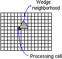
A wedge-shaped neighborhood. The wedge is specified by the start angle, an end angle, and a radius. The wedge extends the radius distance counterclockwise from the starting angle to the ending angle. Angles are specified in degrees, with 0 or 360 representing East. Negative angles may be used.