
Imagery is fundamental to a GIS. Working with imagery as a base layer or for analysis is key to an effective thematic map. Working with imagery means finding the right data for your needs and a good place to start is the World Elevation services.
World Elevation services
The World Elevation services are a collection of multiresolution, multisource elevation data which can be used for viewing and analysis. Esri provides online access to this global collection of elevation imagery which you can use in your desktop and web applications
- For visualization or analysis
- As information layers, such as a hillshade or aspect
- To orthorectify imagery
- As a data source in your analysis models or other geoprocessing tasks
- To obtain data locally
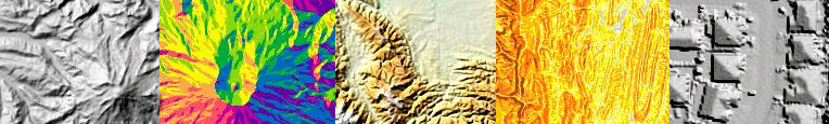
The World Elevation services are image services found on ArcGIS online. They are distinguished as image services for analysis - the actual values - or image services for visualization - the nice-looking imagery. So there are a wide variety of ways you can use the data and ArcGIS makes it easy to pull those services into your map from their hosted location online.
Learn about using the World Elevation services in ArcGIS Desktop
Learn about using the World Elevation services in ArcGIS Online
Mosaic Datasets
If you were to look behind the scenes of the World Elevation services, you would find a mosaic dataset made up of numerous different data sources and formats. If you have your own imagery that you want to use, the mosaic dataset is the optimal data structure to manage, display, and publish your collection. It can manage all different raster file formats and resolutions, and the files are maintained in their original format on disk. The mosaic dataset has many display and processing options as well, so take a look at the help library to see how you can use the mosaic dataset when working with your own imagery.