


 Syntax
| Visual Basic (Declaration) | |
|---|---|
Public Property LayerDrawingOptions As LayerDrawingOptionsCollection | |
| C# | |
|---|---|
public LayerDrawingOptionsCollection LayerDrawingOptions {get; set;} | |
Remarks
Dynamic Layers allow the execution of various ArcGIS Server requests from a client application. An in-depth discussion about Dynamic Layers is in the ArcGISDynamicMapServiceLayer Class documentation. The client side requests that can be issued to ArcGIS Server include the ability to:
- Change the rendering of an existing ArcGISDynamicMapServiceLayer. See the code examples in this document, the ArcGISDynamicMapServiceLayer.CreateDynamicLayerInfosFromLayerInfos Method, and the LayerDrawingOptionsCollection Class.
- Create a layer on-the-fly for the Workspace Types of: Database, Shapefile, FileGDB, and Raster. See the code examples in the ArcGISDynamicMapServiceLayer.DynamicLayerInfos Property and the DynamicLayerInfoCollection Class.
- Perform table joins.
- Query for specific records. See the code example for the QueryDataSource Class.
- Identify features. See the code example for the Tasks.IdentifyParameters.DynamicLayerInfos Property.
- Return raster images.
Dynamic Layers are new in ArcGIS Server v10.1 and require the ArcGIS Runtime SDK 1.0 for WPF and higher.
It is necessary for a Dynamic Layer that will be displayed in a Map Control to have the appropriate Rendering applied. The ArcGISDynamicMapServiceLayer.LayerDrawingOptions Property (which is a LayerDrawingOptionsCollection Class) is used to set the Rendering of each Dynamic Layer. Like the ArcGISDynamicMapServiceLayer.DynamicLayerInfos Property, the ArcGISDynamicMapServiceLayer.LayerDrawingOptions Property is also empty (meaning Nothing/null) when an ArcGISDynamicMapServiceLayer is created in ArcMap and served up via ArcGIS Server.
There is not a specific Method to generate a LayerDrawingOptionsCollection that is pre-populated with existing Rendering options of the sub-layers in an ArcGISDynamicMapServiceLayer similar to the ArcGISDynamicMapServiceLayer.CreateDynamicLayerInfosFromLayerInfos Method. In order create a new Dynamic Layer using the Rendering of a sub-layer that already exists in an ArcGISDynamicMapServiceLayer, one only needs to specify the DynamicLayerInfo.Source to that of an existing LayerMapSource object (see the code example in the LayerDrawingOptionsCollection Class).
When creating a new Dynamic Layer and specifying a custom Rendering make sure that the LayerDrawingOptions.LayerID and DynamicLayerInfo.ID match in order for the Dynamic Layer to draw in the Map.
NOTE: Because creating and using Dynamic Layers requires both ArcGIS Server v10.1 and higher and the development framework of ArcGIS Runtime SDK 1.0 for WPF and higher; use the ArcGISDynamicMapServiceLayer.SupportsDynamicLayers Property to ensure that these conditions have been met.
Example
How to use:
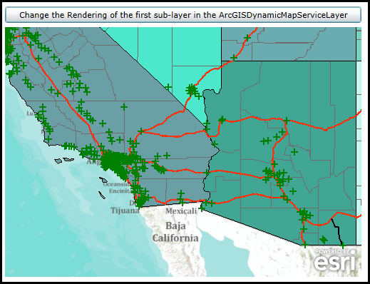
Click the button to change the Rendering of the first sub-layer of the ArcGISDynamimcMapServiceLayer using the Dynamic Layer capabilities of ArcGIS Server 10.1 and higher.
The XAML code in this example is used in conjunction with the code-behind (C# or VB.NET) to demonstrate the functionality.
The following screen shot corresponds to the code example in this page.
| XAML |  Copy Code Copy Code |
|---|---|
<Grid x:Name="LayoutRoot"> <!-- Add a Map Control. Zoom to the South-Western United States. --> <esri:Map Background="White" HorizontalAlignment="Left" Margin="0,180,0,0" Name="Map1" VerticalAlignment="Top" Height="350" Width="500" Extent="-13468458,3546553,-12238506,4578324"> <!--Add a backdrop ArcGISTiledMapServiceLayer. --> <esri:ArcGISTiledMapServiceLayer ID="myArcGISTiledMapServiceLayer" Url="http://services.arcgisonline.com/ArcGIS/rest/services/World_Topo_Map/MapServer" /> <!-- Add an ArcGISDynamicMapServiceLayer. --> <esri:ArcGISDynamicMapServiceLayer ID="myArcGISDynamicMapServiceLayer" Url="http://servicesbeta4.esri.com/arcgis/rest/services/USA/MapServer" /> </esri:Map> <!-- Add a Button to change the Rendering of the first sub-layer of the ArcGISDynamicMapServiceLayer. --> <Button Content="Change the Rendering of the first sub-layer in the ArcGISDynamicMapServiceLayer" Height="23" HorizontalAlignment="Left" Margin="0,151,0,0" Name="Button1" VerticalAlignment="Top" Width="500" Click="Button1_Click"/> <!-- Provide the instructions on how to use the sample code. --> <TextBlock Height="75" HorizontalAlignment="Left" Name="TextBlock1" VerticalAlignment="Top" Width="500" TextWrapping="Wrap" Text="Click the button to change the Rendering of the first sub-layer of the ArcGISDynamimcMapServiceLayer using the Dynamic Layer capabilities of ArcGIS Server 10.1 and higher." /> </Grid> | |
| C# | Copy Code |
|---|---|
private void Button1_Click(object sender, System.Windows.RoutedEventArgs e) { // Get the ArcGISDynamicMapServiceLayer defined in XAML. ESRI.ArcGIS.Client.ArcGISDynamicMapServiceLayer myArcGISDynamicMapServiceLayer = (ESRI.ArcGIS.Client.ArcGISDynamicMapServiceLayer)(Map1.Layers["myArcGISDynamicMapServiceLayer"]); // Using Dynamic Layers to change the symbology of an ArcGISDynamicMapServiceLayer is only avilable on ArcGIS Server 10.1 and higher. double version = myArcGISDynamicMapServiceLayer.Version; if (version >= 10.1) { // Get the DynamicLayerInfoCollection which contains information about the sub-layers of an ArcGISDynamicMapServiceLayer ESRI.ArcGIS.Client.DynamicLayerInfoCollection myDynamicLayerInfoCollection = myArcGISDynamicMapServiceLayer.CreateDynamicLayerInfosFromLayerInfos(); // Get the first sub-layer information (i.e. the 'Cities' or [0] sub-layer) ESRI.ArcGIS.Client.DynamicLayerInfo myDynamicLayerInfo = myDynamicLayerInfoCollection.FirstOrDefault(); // Define a new SimpleMarkerSymbol (a green cross, size 10) ESRI.ArcGIS.Client.Symbols.SimpleMarkerSymbol mySimpleMarkerSymbol = new ESRI.ArcGIS.Client.Symbols.SimpleMarkerSymbol(); mySimpleMarkerSymbol.Style = ESRI.ArcGIS.Client.Symbols.SimpleMarkerSymbol.SimpleMarkerStyle.Cross; mySimpleMarkerSymbol.Color = new System.Windows.Media.SolidColorBrush(Colors.Green); mySimpleMarkerSymbol.Size = 10; // Define a new SimpleRenderer and set the Symbol to the new SymbolMarkerSymbol just created. ESRI.ArcGIS.Client.SimpleRenderer mySimpleRenderer = new ESRI.ArcGIS.Client.SimpleRenderer(); mySimpleRenderer.Symbol = mySimpleMarkerSymbol; // Create a new LayerDrawingOptions object which will change the symbology of the existing first sub-layer of // the ArcGISDynamicMapServiceLayer. ESRI.ArcGIS.Client.LayerDrawingOptions myLayerDrawinOptions = new ESRI.ArcGIS.Client.LayerDrawingOptions(); myLayerDrawinOptions.LayerID = myDynamicLayerInfo.ID; myLayerDrawinOptions.Renderer = mySimpleRenderer; // Create a LayerDrawingOptionsCollection to house the individual LayerDrawingOptions objects. ESRI.ArcGIS.Client.LayerDrawingOptionsCollection myLayerDrawingOptionsCollection = new ESRI.ArcGIS.Client.LayerDrawingOptionsCollection(); // Apply the new settings of the Dynamic Layer and refresh the ArcGISDynamicMapServiceLayer. The Refresh Method // will make this client-side request to the ArcGIS Server to re-render the ArcGISDynamicMapServiceLayer using // the newly defined symbology. myArcGISDynamicMapServiceLayer.LayerDrawingOptions = myLayerDrawingOptionsCollection; myArcGISDynamicMapServiceLayer.LayerDrawingOptions.Add(myLayerDrawinOptions); myArcGISDynamicMapServiceLayer.Refresh(); } else { // Notify the user if using a Dyanmic Layer is not possible. MessageBox.Show("Changing the symbology of a Dynamic Layer not possible. Upgrade to ArcGIS Server 10.1 or higher."); } } | |
| VB.NET | Copy Code |
|---|---|
Private Sub Button1_Click(ByVal sender As System.Object, ByVal e As System.Windows.RoutedEventArgs) ' Get the ArcGISDynamicMapServiceLayer defined in XAML. Dim myArcGISDynamicMapServiceLayer As ESRI.ArcGIS.Client.ArcGISDynamicMapServiceLayer = CType(Map1.Layers("myArcGISDynamicMapServiceLayer"), ESRI.ArcGIS.Client.ArcGISDynamicMapServiceLayer) ' Using Dynamic Layers to change the symbology of an ArcGISDynamicMapServiceLayer is only avilable on ArcGIS Server 10.1 and higher. Dim version As Double = myArcGISDynamicMapServiceLayer.Version If version >= 10.1 Then ' Get the DynamicLayerInfoCollection which contains information about the sub-layers of an ArcGISDynamicMapServiceLayer Dim myDynamicLayerInfoCollection As ESRI.ArcGIS.Client.DynamicLayerInfoCollection = myArcGISDynamicMapServiceLayer.CreateDynamicLayerInfosFromLayerInfos ' Get the first sub-layer information (i.e. the 'Cities' or [0] sub-layer) Dim myDynamicLayerInfo As ESRI.ArcGIS.Client.DynamicLayerInfo = myDynamicLayerInfoCollection.FirstOrDefault ' Define a new SimpleMarkerSymbol (a green cross, size 10) Dim mySimpleMarkerSymbol As New ESRI.ArcGIS.Client.Symbols.SimpleMarkerSymbol mySimpleMarkerSymbol.Style = ESRI.ArcGIS.Client.Symbols.SimpleMarkerSymbol.SimpleMarkerStyle.Cross mySimpleMarkerSymbol.Color = New System.Windows.Media.SolidColorBrush(Colors.Green) mySimpleMarkerSymbol.Size = 10 ' Define a new SimpleRenderer and set the Symbol to the new SymbolMarkerSymbol just created. Dim mySimpleRenderer As New ESRI.ArcGIS.Client.SimpleRenderer mySimpleRenderer.Symbol = mySimpleMarkerSymbol ' Create a new LayerDrawingOptions object which will change the symbology of the existing first sub-layer of ' the ArcGISDynamicMapServiceLayer. Dim myLayerDrawinOptions As New ESRI.ArcGIS.Client.LayerDrawingOptions myLayerDrawinOptions.LayerID = myDynamicLayerInfo.ID myLayerDrawinOptions.Renderer = mySimpleRenderer ' Create a LayerDrawingOptionsCollection to house the individual LayerDrawingOptions objects. Dim myLayerDrawingOptionsCollection As New ESRI.ArcGIS.Client.LayerDrawingOptionsCollection ' Apply the new settings of the Dynamic Layer and refresh the ArcGISDynamicMapServiceLayer. The Refresh Method ' will make this client-side request to the ArcGIS Server to re-render the ArcGISDynamicMapServiceLayer using ' the newly defined symbology. myArcGISDynamicMapServiceLayer.LayerDrawingOptions = myLayerDrawingOptionsCollection myArcGISDynamicMapServiceLayer.LayerDrawingOptions.Add(myLayerDrawinOptions) myArcGISDynamicMapServiceLayer.Refresh() Else ' Notify the user if using a Dyanmic Layer is not possible. MessageBox.Show("Changing the symbology of a Dynamic Layer not possible. Upgrade to ArcGIS Server 10.1 or higher.") End If End Sub | |
Requirements
Target Platforms: Windows XP Professional, Windows Server 2003 family, Windows Vista, Windows Server 2008 family, Windows 7, Windows 8