Esri Production Mapping helps organizations achieve economies of scale by creating, managing, and publishing standardized data and cartographic products on strict schedules.
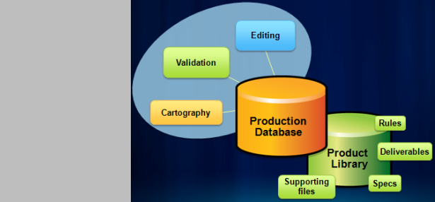
Centrally store and manage production related information such as business rules, documents, workflows and spatial information to standardize your data and map production processes.
Read more...
Create, execute, manage, and distribute GIS workflows to ensure standardization and consistency across operations as well as to easily track workflow status, progress, resource assignment, and completion.
Read more...
Centralized attribute management, on-the-fly and post edit validation, feature level metadata management, customized attribute display, additional feature templates.
Read more...
Repeatable and automated process to create and maintain map outputs from a GIS with support for enterprise cartographic production workflows.
Read more...The 2016 User Conference is almost upon us! We still have some spots left if you’re interested in getting your GIS data’s quality assessed by an Esri expert. For more information on how to sign-up please check out the original … Continue reading
Esri is, once again, offering the free GIS data health checks at this year’s User Conference. In 2011, Esri provided water/wastewater customers an opportunity to see just how clean their data really is. Since then, the Data Health Checks, as … Continue reading
Every day, you make decisions based on the assumption that your GIS data is complete and accurate. The positional accuracy of this data is an important aspect in determining its fitness for use. The Data Reviewer team is pleased to … Continue reading
The Data Reviewer team is pleased to announce the release of two new widgets – Report Feature and Reviewer Dashboard – for the Web AppBuilder for ArcGIS v1.2 Developer Edition. The widgets leverage services found in ArcGIS Data Reviewer for … Continue reading
If you are an electric/gas user who missed signing up for a GIS data health check at the UC 2015, you’ll be glad to hear that Esri is offering this at the Electric & Gas GIS Conference in Providence, RI, Oct … Continue reading


")
")

")
")
")
")
")
")


")
