Esri is taking GIS to a new depth . Scroll down for more...

As a company with the mission to inspire and enable people to positively impact their future through a deeper geographic understanding of the changing world around them. Esri recognizes that this understanding must involve a strong commitment to the oceans.
Read More...
Learn how your organization can contribute to the Ocean Basemap.
Read more...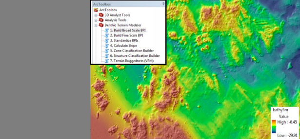
The Benthic Terrain Modeler is a set of geoprocessing tools to analyze benthic terrain for the purposes of classifying surficial seafloor characteristics.
Read more...We had a very busy Esri Developer Summit last week. It was great to meet and talk with many users about Operations Dashboard for ArcGIS in the exhibit showcase, after our technical sessions, and during the social events. There was … Continue reading
The Critical Content for Disaster Response available in ArcGIS Living Atlas of the World Part 1 and Critical Content for Disaster Response available in ArcGIS Living Atlas of the World Part 2 recordings are now available! Natural disasters have dramatically … Continue reading
The ArcGIS Living Atlas of the World website has been redesigned to make learning, using, and contributing to the Living Atlas effortless. In addition to improving search, three new pages were added to the website: Browse, Apps, and Blogs. The … Continue reading
Applying GIS tools to urban planning projects sometimes entails working with tens of thousands of features. Determining the number of bus stops in a city, houses in a town, or streets in a county are a few examples. GeoPlanner for … Continue reading
Each of our development teams recorded a short video to show off what they have built for this release and we’ve compiled them all into a grand tour. Each section focuses on a different piece of functionality. To see specific … Continue reading


