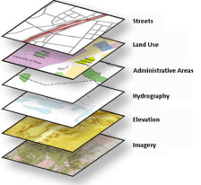
ArcGIS allows you to build powerful maps and applications using geographic data. A good map, and therefore a good GIS, is a collection of thematic layers that lets you identify relationships and trends in your data, perform spatial analysis, and improve planning and design strategies.
Esri provides a number of useful maps and applications on the ArcGIS Resouce Center. These maps and apps are built from pre-configured information models that cater to specific communities. A good place to start working with geographic data is to browse the maps and apps suitable to your community or industry, download an appropriate template and see what's inside.
Once you look inside a template, you'll notice that the geographic data within is stored in a geodatabase. The geodatabase is a key component of a GIS and is responsible for much of the functionality found within the maps and apps on the ArcGIS Resouce Center.
The video below takes the Campus Place Finder application and dissects it to show how most of the functionality in the app is governed by the underlying geodatabase where the data is stored.
The geodatabase
The geodatabase is a collection of thematic layers which you can present and overlay on a map. Layers such as the buildings, interior spaces, paved areas, and trees that are shown in the Campus Place Finder app. The geodatabase stores and organizes your geographic data as points, lines, polygons and attributes with which you model these real world entities.
As seen in the video, the geodatabase also adds value to your geographic data by enhancing thematic layers with integrity rules and geographic behavior that you define. Your data becomes smarter and more self-aware through spatial and relational integrity rules, data validation, and advanced business logic.
To further enhance your geographic data, the geodatabase also allows you to create thematic layers with more advanced behavior, such as:
- Connected pipelines that model flow direction
- Parcel and building layers with rules to maintain their geometric coincidence
- Transportation networks with travel times and turns for route analysis
- Geocoded addresses for location services
- Elevation, terrain and 3D surfaces
- Mosaicked imagery for mapping, reconnaissance, and scientific study
These more advanced thematic layers allow maps and apps to more accurately model real world behavior and scenarios, perform predictive analysis, and make informed business decisions.
With these features and more it's easy to see why the geodatabase is fundamental to working with geographic data, to creating great maps and applications, and to building the foundation of a solid GIS.
Visit the ArcGIS help library to learn more about the geodatabase and how you work with your geographic data.
To find an information model that fits your specific community or industry, visit the communities section of the Resouce Center.


